Places
Neun Gemeinden, eine Stadt, eine Region Rhein-Nahe
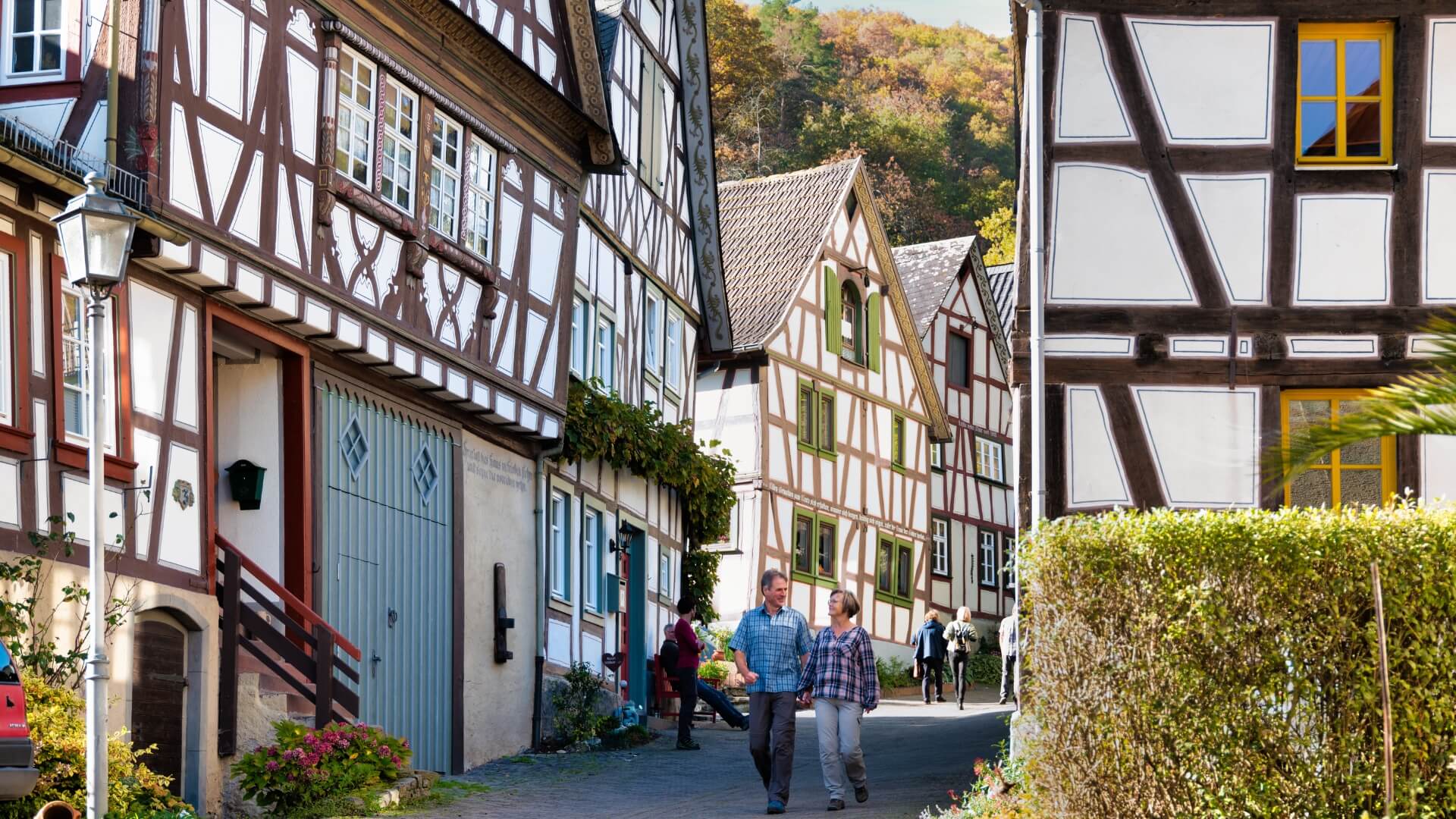
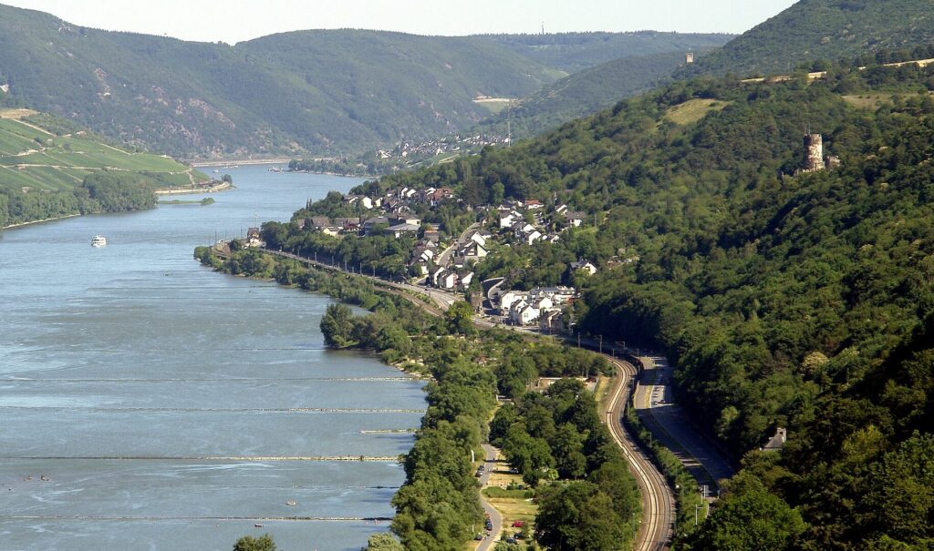
Bacharach was first mentioned in a document in 871. Bacharach owes its reputation from time immemorial to its viticulture and wine trade. Already in the Middle Ages, the town had a world-wide reputation as the main stacking place for the Middle Rhine, Nahe and Rheingau wines and was one of the most famous wine towns.
Bacharach is the tourist resort of the municipality. The medieval townscape with the old city fortifications, Stahleck Castle (one of the most beautiful youth hostels in the Rhine Valley), the Gothic Werner Chapel, as well as the ruins of Stahlberg in the Steeg district, exerted a strong attraction on travelers early on. An extensive network of hiking trails, boat trips on the Rhine, wine tasting, cozy restaurants and hotels, offers guests a varied offer of recreation and relaxation.
Bacharach
Sights:
Old House; marketplace; Werner Chapel; Old Post Office; St. Peter's Lutheran Church; Stahleck Castle; Zollhof with St. Nicholas Catholic Church; Electoral Palatine Mint (former mint); Electoral Palatine Amtskeller (now City Hall); largely preserved city fortifications (ring wall and towers); numerous picturesque half-timbered houses in Bacharach and Steeg district; St. Anne's Lutheran Church in Steeg; Stahlberg castle ruins in Steeg ; Roman road.
in the district "Kühlberg".
(ca. 1.600 Einwohner, 23,35 km² Fläche)
Today's local community Breitscheid is inseparably connected with the development and events of the "Viertälergebiet", which can also be seen in a document from the year 1250. Breitscheid is the smallest municipality in the municipality and at the same time the northernmost and highest municipality in the district of Mainz-Bingen. The rural residential and recreational village is nestled in fields and meadows, sheltered from the wind in a hollow. Here the world has remained intact, here you will find an unspoiled spot on earth.
(ca. 150 Einwohner, 5,31 km² Fläche)
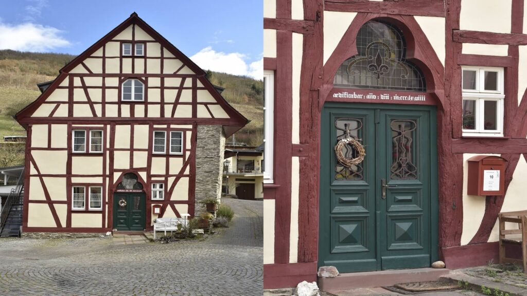
Manubach was first mentioned in documents together with Oberdiebach on April 1, 1190. The occasion for this was the ordering of the tax relations of the estates of Count Berthold. However, as one of the "Viertälergemeinden" (four-valley communities), settlement can be assumed as far back as the younger Stone Age. Manubach lived from agriculture, today especially from viticulture, which has been growing and pressed here in extreme steep slopes for centuries. Lovers of old half-timbered houses get their money's worth here. Lovingly restored farmhouses and winegrowers' houses in large numbers make Manubach a gem in the Verbandsgemeinde.
Church of St. Oswald in Manubach
Sights:
Carvings in St. Oswald's Church; numerous half-timbered houses.
(ca. 300 Einwohner, 7,67 km² Fläche)
On October 1, 1928, the two independent communities of Münster and Sarmsheim were merged to form today's double community of Münster-Sarmsheim. Finds from the Neolithic and Hallstatt periods indicate the earliest settlement. The Romans brought wine to the Nahe, which is still cultivated today by industrious winegrowers on sunny slopes. The guest can taste it in numerous wineries, cheerful wine taverns, estate taverns and cultivated restaurants. Münster-Sarmsheim on the Nahe Wine Route is a modern residential community with a lively club life. Visible from afar, the landmark is the Stumpfe Turm, which was built around 1490 due to a market dispute between Bingen and Münster-Sarmsheim.
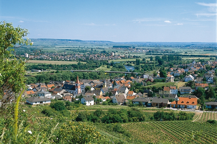
View of Sarmsheim Minster
Sights:
Peter and Paul Parish Church; St. Alban's Church; Old Town Hall; Stumpfer Tower Ruin; Trollbach Valley Nature Reserve with rock formations and Lower Nahe ("Coffee Pot" and "Camel"), Rhine-Nahe Loop Premium Circular Hiking Trail.
(ca. 3.000 Einwohner, 6,92 km² Fläche)
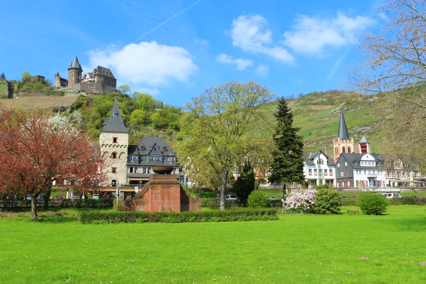
Niederheimbach in the Rhine-Nahe forest recreation area is nestled in the Rhine and Heimbach valleys, overlooked by Heimburg Castle, built in 1290. The village was mentioned in documents as early as 983. Remains of the old fortification wall still stand along the Heimbach. Sooneck Castle, which also belongs to Niederheimbach
and built in 1011, was once a feared nest of robber barons. Today it is under state administration and serves as a museum for tourists. Niederheimbach is a well-known wine village and offers every guest a relaxing stay. Hikes through the surrounding beech and fir forests, among others to the Siebenburgenblick, are always an experience. Niederheimbach is easy to reach by bus, train and boat.
Sights:
Hohneck Castle (home castle); Sooneck Castle; Siebenburgblick; "artist" - train station; castle nursery (concerts in the wine greenhouse); biotope Kuhweg; parish church Maria Himmelfahrt; wine trail, premium circular hiking trail Schellengang, hiking trail "Rhine over".
(ca. 800 Einwohner, 7,55 km² Fläche)
Oberdiebach liegt in einem stillen Seitental des romantisch es Mittelrheins und wird 893 erstmals urkundlich erwähnt. Auf den rebenbestandenen Hängen in und um Oberdiebach wird seit mehr als einem halben Jahrtausend Riesling-Weinbau betrieben. Auf den gut ausgeschilderten Wanderwegen offenbaren sich einem Erholungssuchenden herrliche Ausblicke von den Rheinhöhen. Die bekanntesten Weinlagen sind Fürstenberg und Bischofshub. Gepflegte und ruhige Gaststätten und Pensionen laden zum längeren Verweilen ein.
(ca. 800 Einwohner, 8,36 km² Fläche)
Oberdiebach, district Rheindiebach
Oldest gothic half-timbered house on the Middle Rhine, Am Kräuterberg 10 (private)
Sights:
St. Moritz Church; half-timbered houses (Am Kräuterberg 10, post-and-beam construction from 1368); Fürstenberg ruins; Rhein-Burgen-Schutzhütte lookout point; Schellengang premium circular hiking trail.
(about 850 inhabitants, 855 ha area)
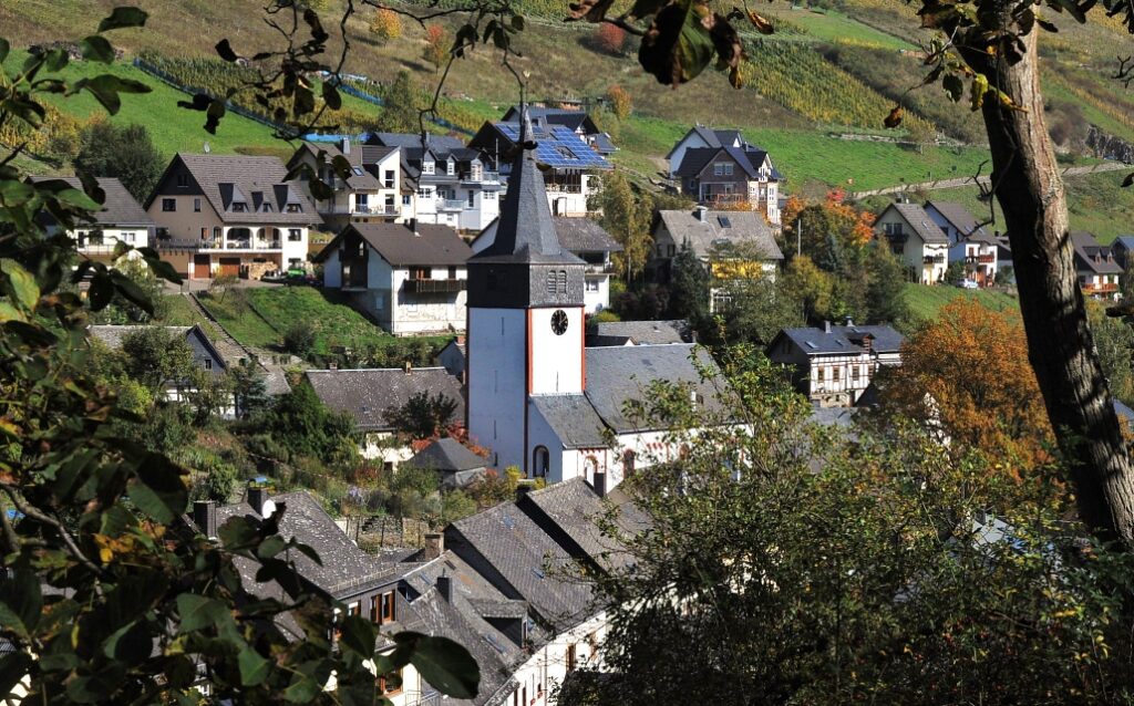
The wine-growing community of Oberheimbach, first mentioned in a document in 1050, is located in the idyllic Heimbach Valley, surrounded by forests and vineyards. Originally engaged in cattle and arable farming, the population turned more and more to viticulture, which today plays a dominant role. In 1920, when phylloxera destroyed a large part of the vineyards, threatening the existence of the winegrowers, they joined forces in their distress. The Heimbach valley was declared the first vine-growing area. The vines were gradually replaced by grape varieties resistant to phylloxera and, together with land consolidation, the basis for healthy vineyards was created. In addition to viticulture, tourism
tourism becomes more and more important.
Sights:
Holy Cross Chapel built by monks in the early 12th century A.D.; parish church.
St. Margaret
(ca. 500 Einwohner, 8,73 km² Fläche)
Trechtingshausen was first mentioned in a document in 1122, but the chronicler already speaks of a "Castrum Trajani" in Roman times. However, the development of the village is inseparably connected with the history of the castles Rheinstein and Reichenstein built in the Middle Ages, the latter a formerly feared nest of robber barons. Also worth seeing is the Clemens Chapel on the banks of the Rhine, built in the 12th century. Today, the recognized tourist community has 1,050 inhabitants and offers guests the genuine romance of the Rhine and castles. A good infrastructure is available. Numerous associations bear witness to an intact village community. In the competition "Our village has a future" Trechtingshausen has already won the state competition.
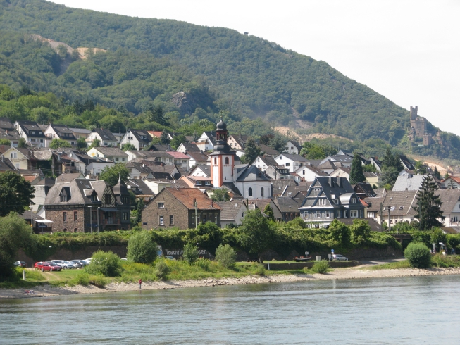
View of Trechtingshausen
Sights:
Rheinstein Castle; Reichenstein Castle; Clemens Chapel; Old fortification; Museum of Local History.
(ca. 1.000 Einwohner, 7,67 km² Fläche) Website Trechtingshausen
Lokale Rundwanderwege in Trechtingshausen:
- Download "Übersichtskarte Rundwanderwege"
- Download "Schweizerhaus-Runde"
- Download "Gerhardhof-Runde"
- Download "Eselspfad"
- Download "Zur Kölschwiese"
- Download "Zum Hagelkreuz"
- Download "Historische Runde Trechtingshausen"
Quelle: Heimatverein Trechtingshausen und Burg Reichenstein
Waldalgesheim, a local community more than 1200 years old, is situated on the Bingen Heights at the gateway to Hunsrück and is an up-and-coming residential community with a high recreational value. Waldalgesheim became widely known through the mining of manganese ores from the end of the 19th century until 1971.
The castle-like mining facilities with the winding tower led to the mine being regarded as the "Colliery Castle in the Bingen Forest" and as an industrial monument of national importance. A lively club life with numerous events, many of them in the Celtic Hall built in 1991, ensures that everyone soon feels at home. With the transformation from a farming village to a mining village and today to a popular residential community with a small business park, Waldalgesheim has moved with the times. Fruity Nahe wines and a cultivated gastronomy leave nothing to be desired. The district of Genheim has received a new, attractive village center through the reconstruction and renovation of the "Old School". Waldalgesheim and the district of Genheim will soon be spatially connected by a new residential area on Römerstraße. The local community of Waldalgesheim attaches great importance to integrating young and old. Everyone should feel comfortable in Waldalgesheim and find a home.
Sights:
Grube Doktor Geier (largest manganese ore mine in Germany); Celtic ornaments in the town hall; Old School Genheim; Protestant Church in Genheim; Forest, Wine and Wildlife Trail, Premium Circular Hiking Trail Rhine-Nahe Loop.
(ca. 4.000 Einwohner, 16 km² Fläche)
Finds from the Stone Age already indicate an early settlement. Weiler was first mentioned in a document of Emperor Louis the Pious in 823. Originally characterized by agriculture and forestry (approx. 2000 hectares of forest), the structure of the workforce changed with the development of the railroad and the mining of manganese ores in Waldalgesheim. Agriculture is of little importance today, but not viticulture, whose wineries produce excellent Nahe wines. The pretty and scenically situated village of Weiler is known beyond its borders for its active club life, which benefits from the Rhine-Nahe Hall and the associated sports and recreational facilities. The village renewal takes a high priority. All plans and measures are aimed at making the community even more attractive to live in and at the same time preserving the substance of the village, which is located at the junction of the Rhine, the Hunsrück and the
Hunsrück and the surrounding area.
Sights:
Old village center; village square with village fountain; St. Maria Magdalena Catholic parish church; Celtic ring; burial mounds; forest botanical garden north of Heilig-Kreuz forester's lodge; Roman excavations
in the Bingen Forest; Memorial "Belle Kreuz", Premium Circular Hiking Trail Rhine-Nahe Loop
(ca. 2.400 Einwohner, 22,79 km² Fläche)


